| N23°55.00 E97°42.00 |
Off Topic: Locating Loiwing airstrip(s), Yunnan, China Page 3 of 6 : Loiwing Aerodrome |
Route NA |
| Text | Notes | |||
|
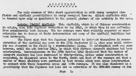
Little was known about the history of this air facility before WWII. It did exist in 1942[35a], when Dudley Wood seemed to define it as a separate air facility in a visit in April 1942. But, in that light, a re‑examination of the record of events during that period verifies its existence and strongly supports its importance, as a separate entity, distinct from Loiwing's Factory strip. Dan Gourley, advance man with the duty to pick a site for the CAMCO factory, arrived in November 1938, apparently by car from Rangoon, and the factory manager, Mr "Chuck" Hunter, followed by the Burma Road from Kunming.[36] Had Suili existed at that date, in consideration of the importance of the CAMCO operation and the tight schedule for its relocation, both Gourley and Hunter presumably would have continued their flights from Rangoon and Kunming respectively, straight into Suili, rather than having taken the road. Allied intel provided this late introduction in 1944 to the Suili air facility in its Airfield Report No 21:[37]
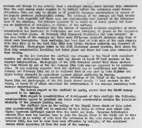
Partial transcription: Airfields The main concern of this short appreciation is with enemy occupied airfields . . . in enemy occupied Yunnan. . . . Loiwing (Suili) Airfield: This airfield, which is of Chinese construction in origin, came into Japanese occupation in May 1942 . . . . . . . Reconnaissance on the 28th October 1942 . . . disclosed a possibility that the Japanese had laid out an extension of the WNW-ESE runway as its [p1→p2] western end though it was notable that a canalized stream which divided this extension from the main runway would require to be bridged before the extension could become effective. This can only be stated as of possible Japanese construction by reason of the Japs [?] to previous photographic cover. The drainage of the runways and land tracks had also been improved and three AA gun emplacements were located at the intersection of the runways. The runways appeared to be built up of local gravel and there was no indication of metalling or tarring of the surface. By the 1st December 1942 the number of aircraft shelters completed or under construction had increased to forty-nine and some leveling of ground in the diagonal areas had taken place. In February 1943 dispersal facilities had been extended in the area north of the runways and there were fifty-one aircraft shelters only four of which were incomplete. Some surfacing had been done at both ends of the main runway. From this time up to the 21st July 1943 very little further activity was observed at the airfield. Photographs taken on the 18th September showed however, that since the 21st July considerable leveling had taken place and there had been some extension of taxi tracks. On the 3rd November [1943] the airfield was attacked by the USAAF with excellent results and photographs taken the next day showed at least 50 bomb craters at the runways intersection. Photographs of the 19th November showed that those craters had been filled in and on the 2nd January 1944 both runways appeared to be serviceable. It was reliably reported that the airfield was in operational use during January and February 1944 and it is believed that it was used by both fighter and light bomber aircraft in operations against Allied airfields in Yunnan. The airfield again received the attention of the USAAF at the beginning of March 1944 and photographs of the 6th March showed nearly 60 bomb craters on the field, at least 50 of which straddled the intersection of the runways rendering both runways unserviceable. The latest report on the airfield in April, stated that the NE-SW runway appeared to be usable. With regard to possibilities of development of this airfield the following considerations appear to preclude any large scale construction outside the immediate vicinity of the present landing area. The airfield lies in the valley of the Shweli River which at this point runs approximately NE-SW and is enclosed by high hills on either side which make flying approach difficult except from the south and east. Numerous tributarial streams flow near the landing area to join the Shweli River to the south and in this connection it is worthy of note that the extension to the main runway first seen in October 9142, has not to date been made effective by bridging of the canalized stream which separates it from the rest of the runway. In general, the text indicates that early on, the Japanese had made some improvements to the facility; the Allies saw the facility's potential and had targeted it more than once, with the Japanese responding with timely repairs. Particularly useful in the text above is a clue, however awkwardly stated, to Suili's origin: "This airfield, which is of Chinese construction in origin . . ."
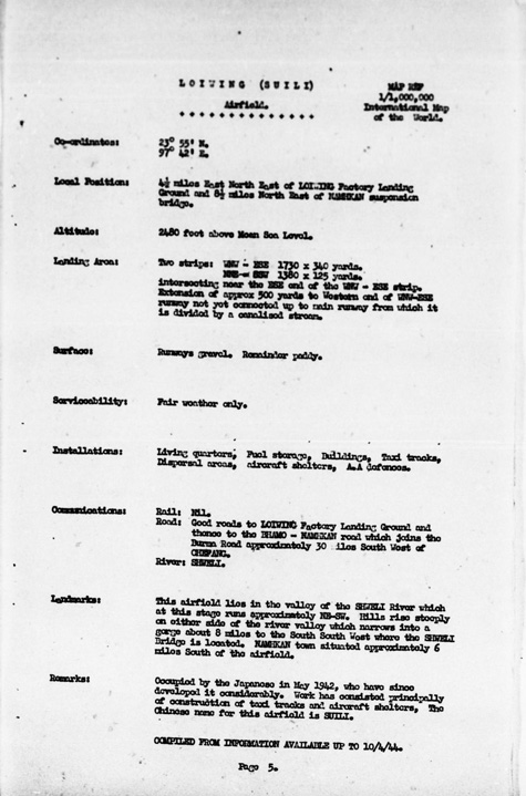
High resolution image is available here. And a text description of Loiwing Airdrome:[39]
Higher resolution image available here.
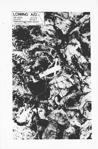
Items of particular interest: • "Coordinates": for the intersection of the two runways, Additionally: • The north arrow on the aerial photo was found to be only
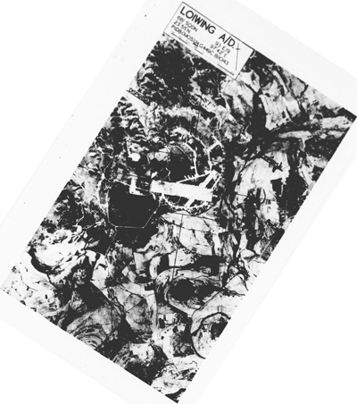
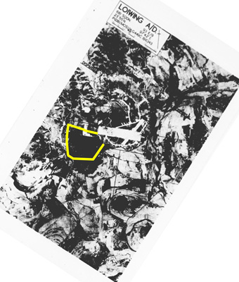
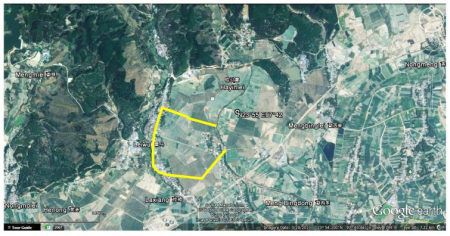
The coordinates provided in the text description seemed to have been rounded to whole minutes: this broadened the possible location of the intersection of the runways to an area of about 1.9km x 1.7km (from N23°54.5' to N23°55.5' and from E97°41.5' to E97°42.5'). Ultimately, I found that the coordinates were almost spot on --- ie, in whole minutes; but of course I didn't know that until I had looked at Google Earth (GE) terrain for quite some time: evidence on the ground of the runway wasn't immediately clear. Eventually, I was able to match some distinctly aligned roads on the ground to old airport perimeter roads and I used them to align the aerial photo to GE: Aerial photo:[41]
High resolution image available here. Google Earth:[42]
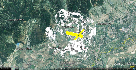
High resolution image available here. Combined:[43]
High resolution image available here. Final product:[44]
High resolution image available here. It is not known if the perimeter roads (or taxi tracks, or whatever they might have been) that allowed this identification were constructed by the Nationalist Chinese or later by the IJA / IJAAF. Lieuwe Montsma nicely summarized the result using an aerial photo found by Matt Poole:[44a]
|
Reminder: Loiwing Aerodrome, Loiwing (Suili), EiYun, Awlaw, Suili, Ruili, Juili, Shweli, Su-li, Ju-li, Namsham, Namshan, and Loping were all found to refer to the same airstrip, though the last, Loping, was later found to be in error. 35a.^ It was recently found to have been completed in October 1941. See below. 36.^ Seagrave in Burma Surgeon, ibid, pp 95-96.
37.^ Airfield Report No 21, April 1944, pp 1, 2 (USAF Archive microfilm roll A8055 pp 0627-0628). Enhanced with IrfanView by author.
38.^ Airfield Report No 21, April 1944, photo date 08 Oct 1943, following numbered p 5 (USAF Archive microfilm roll A8055 p0631). Enhanced with IrfanView by author.
39.^ Airfield Report No 21, April 1944, p 5 (USAF Archive microfilm roll A8055, p 0631). Enhanced with IrfanView by author.
40.^ Coordinates and realignment per Google Earth. Airfield Report No 21, April 1944, photo date 08 Oct 1943, following numbered p 5 (USAF Archive microfilm roll A8055 p0631). Image tilted 33 degrees clockwise and enhanced with IrfanView by author.
41.^ Airfield Report No 21, April 1944, photo date 08 Oct 1943, following numbered p 5 (USAF Archive microfilm roll A8055 p0631). Image tilted 33 degrees clockwise and enhanced with IrfanView, and annotated using Microsoft Publisher, by author.
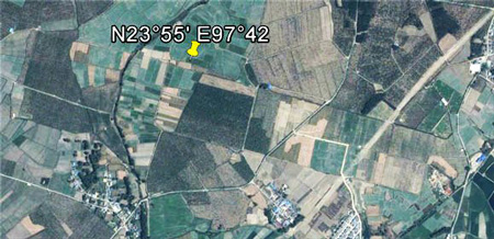
42.^Google Earth view of N23°54.90 E97°41.90 at eye alt 7.22km. Image captured with Gadwin PrintScreen, enhanced with IrfanView and annotated using Microsoft Publisher, by author.
43.^ Google Earth view of N23°54.90 E97°41.90 at eye alt 11.56km. Underlying image captured by Gadwin PrintScreen, enhanced with IrfanView and annotated using Microsoft Publisher, by author. Overlay by author using Adobe PrintShop.
44.^ ibid.
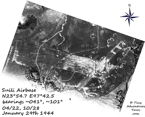
44a.^ Image dated 29 Jan 1944, provided by Matt Poole from NARA records (image MP9416,FrD14,Suili,dark-1 by email of 1004 hrs 09 Dec 2014). Image realigned so that north is up-page and annotated by Lieuwe Montsma. Image enhanced with IrfanView by author.
44a1.^ Dan Ford post on Warbirds Forum 1810 23 Dec 2014. Image enhanced with IrfanView by author.
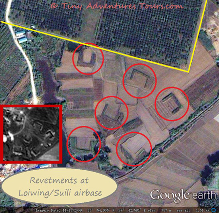
44b.^ 29 Jan 1944 aerial photo (provided by Matt Poole from NARA records (image MP9416,FrD14,Suili,dark-1 by email of 1004 hrs 09 Dec 2014)) overlaid on Google Earth view of Suili area (using GE historical imagery dated 13 Nov 2009 which best shows revetments) by Lieuwe Montsma (per att to email of 1453 11 Jan 15).
44c.^ Lieuwe Montsma, ibid, and Dan Ford post of 1639 13 Jan 2015. Image enhanced with IrfanView by author. The Mins (see below) caution that what are here termed "revetments" were called something they felt were very different in Chinese: "aircraft shelters".
44d.^ Per description by Li‑yan, Yunnan Museum Archives, to Wang Min and Lu Min by email. Document was subsequently forwarded to Dan Ford, who passed it to me (att to Ford email of 0340 17 Jan 2015).
45.^ Ford, Daniel, Flying Tigers (Washington: Smithsonian, 2007), pp‑259‑260.
46.^ Ford, ibid, pp 276-282. 46a.^ The IJA entered Lashio on 29 Apr 1942 (Greenlaw, ibid, p 159).
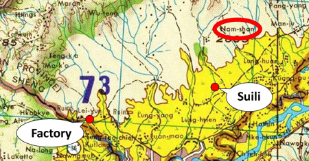
47.^ "ick53993" on Yuku Warbirds' Loiwing thread seems first to have associated Namsham with the Loiwing's eastern component, ie, Suili --- (post of 06 Oct 2007 0534 hrs). 47a.^ Hsenwi, ibid, excerpt, extracted and enhanced using IrfanView and annotated with Microsoft Publisher, by author.
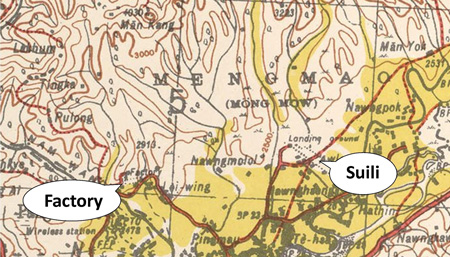
48.^ Extract from Hsenwi, Burma, China map, NF47-2 (St Louis: US DoD, June 1967); part pdf image captured with Gadwin PrintScreen, enhanced with IrfanView, and annotated with Microsoft Publisher, by author. The name, Nam-sham, also appeared in the previous map issue: Hsenwi map, NF47-2 (Washington: Army Map Service (AMS) (GUVLB), 1958). However, as noted, it doesn't appear on the pre-WWII UK Hsenwi map, F-47B (Provisional GSGS 4218 (Survey of India, third edition); reprinted by Washington: Army Map Service, 1944).
49.^ Letter of 12 January 2015 from Wang Min and Lu Min to Dan Ford (copy provided by Ford).
|
